Palynology, Palaeoecology and Biogeography
Our lab is dedicated to palaeoecological and biogeographic research developing and integrating high-resolution palaeoenvironmental records from across the Southern Hemisphere, primarily in Australia, using multiple proxies to provide comprehensive reconstructions of environmental change over time. Integral to our laboratory and research is working and developing research projects with Traditional Owners, who are striving to engage with and return health to their Country.
Key areas of research include:
- How Aboriginal and Torres Strait Islanders – Australia’s First Peoples – have used fire to manage, manipulate and create Australian vegetation landscapes since arriving more than 68,000 years ago;
- How fuel loads, fuel type, fire frequency and fire intensity have changed across Australia during the transition from Indigenous to British management over the past 500 years;
- Meaningfully incorporating Indigenous knowledge into landscape management to tackle many of the environmental challenges we face today (restoration and management guidelines);
- Historic vegetation, fire, and hydrological fluctuations across landscapes;
- Response, resilience and recovery of endangered ecologies and ecosystems.
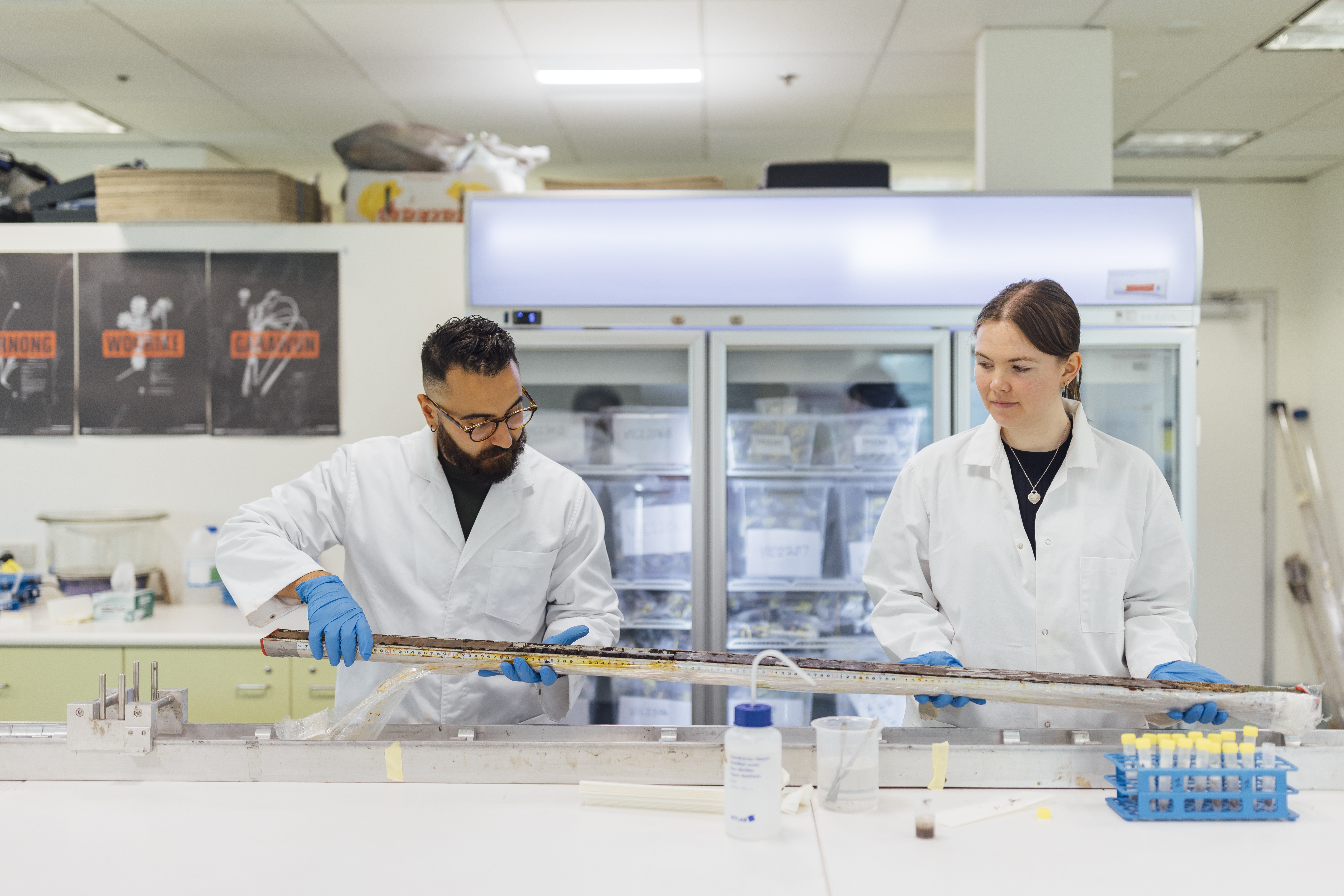
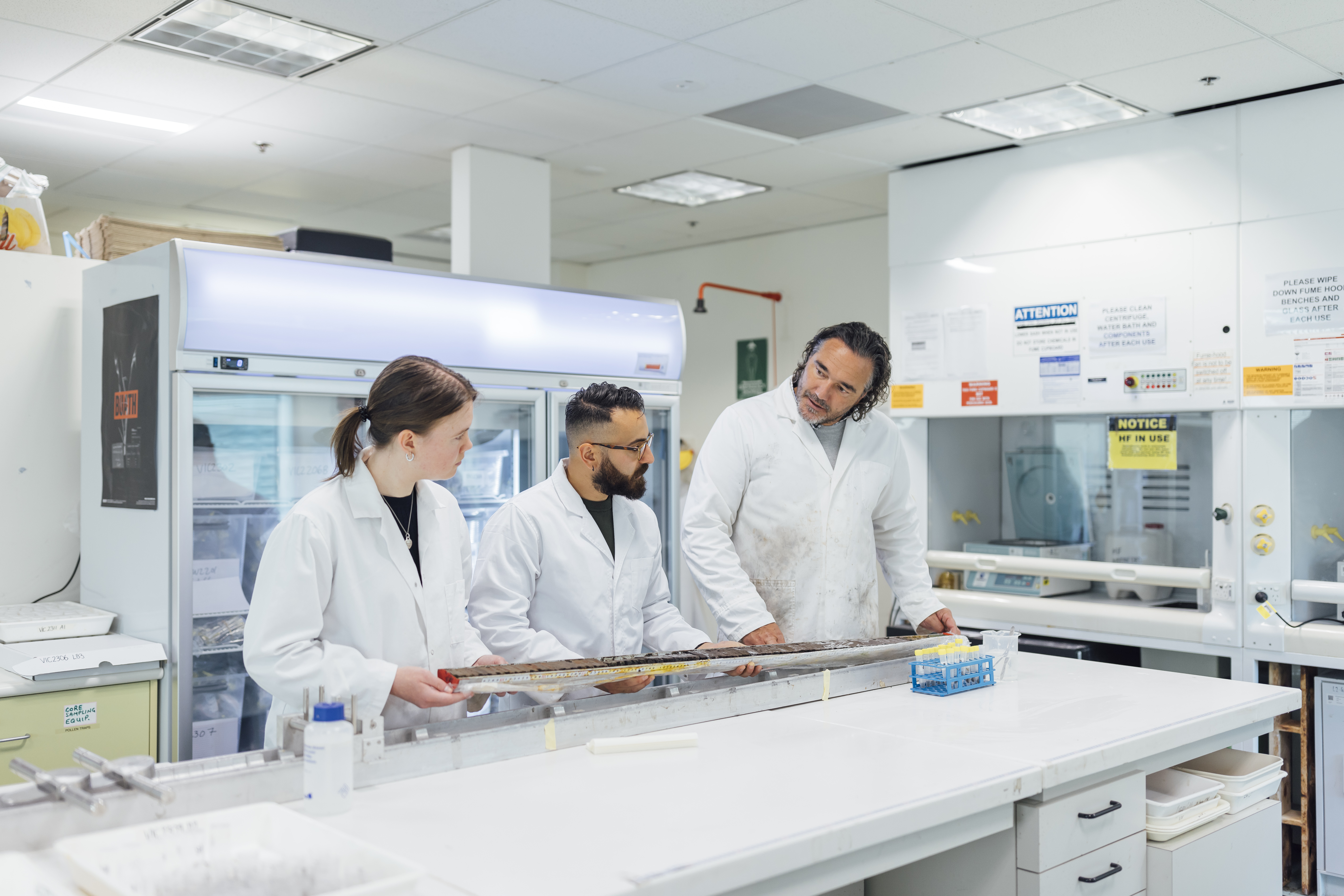
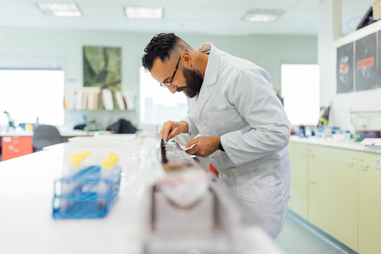
We are based in the School of Geography, Earth and Atmospheric Sciences at The University of Melbourne. Our research is undertaken using various techniques including the collection, analysis and synthesis of paleoenvironmental data (employing the multi-proxy approach), primarily from sediment cores from wetlands, but also includes tree rings and speleothems. The main proxy indictors we work with are pollen (for vegetation reconstructions) and charcoal (for insights into fire activity). With our numerous collaborations with researchers and laboratories in Australia and worldwide we also employ geochemical, isotopic and sedimentological proxies to assist in answering fundamental questions concerning the Earth system and the role of humans within it. We work closely with Traditional Owners to develop research projects that are led by their aspirations for Country and are designed to serve the purpose of returning health to Australian environments, to Country.
Our laboratory


Our partners
Events

News
Contact
For enquiries, please email Mr Anthony Romano anthony.romano@unimelb.edu.au or Professor Michael-Shawn Fletcher - michael.fletcher@unimelb.edu.au
Researchers and graduate research students in the Palynology, Palaeoecology and Biogeography Research Lab.
Academic staff
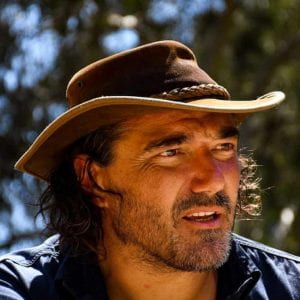
Prof Michael-Shawn Fletcher
My research focuses on the long-term interactions between humans, climate, disturbance and vegetation at local, regional and global scales.
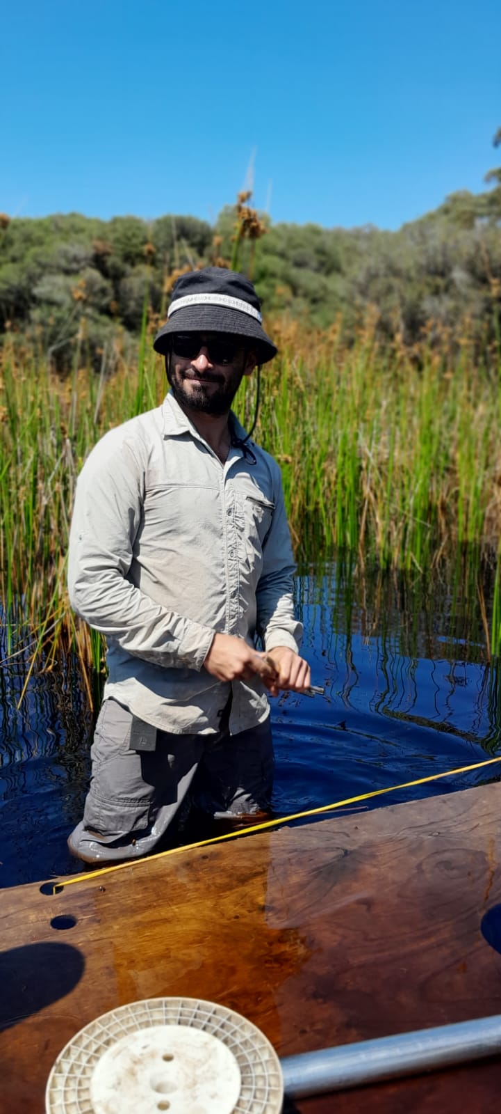
Mr Anthony Romano
My research focuses on relationships between humans, fire, vegetation and climate, blending archaeology with palaeoecology.
Dr William Henriquez Gonzalez
My research focuses on long-term climate, vegetation and fire changes across the mid-southern latitudes.
PhD students
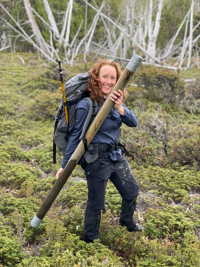
Sarah Cooley
My research explores the response, resilience and post-fire recovery of the endemic conifer of Tasmania - Pencil Pine, throughout the Holocene (past 10,000 years to present) to understand how best to target appropriate management of these threatened species in the face of climate and land-use change.
Patrick Kennedy
My research aims to reconstruct trends in fire regimes and fuel loads throughout the Holocene, with a particular interest in understanding of the impacts of British Invasion (and the loss of indigenous burning)
Louisa Sheridan
My research interests lie at the intersection of palaeoecology, fire, climate change and broad earth systems. My work has involved producing high-resolution palaeoclimate records that illuminate historical climate change in the Southern Hemisphere.
Anthony Romano (PhD)
My PhD project is focusing on palaeoecological research (e.g. fire, vegetation, flooding) from across Taungurung Country (Eastern Victoria) to explore the different types of Country; their histories, stories and changes since British Invasion. I will also incorporate archaeological data and LiDAR in this project.
Graduate researchers

Harriet Magee
Ashleigh Hallinan
Brittney Taylor
Nina Wiederkehr
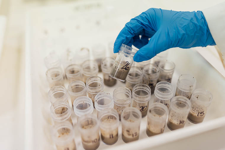
Our research focuses on looking into the past through sediment archives, retrieved from wetlands, to uncover the legacy of Indigenous Care for Country across Australia. We investigate changes in vegetation and fire over decades to thousands of years to reconstruct environments over time and highlight the integral role of people in ecosystems.
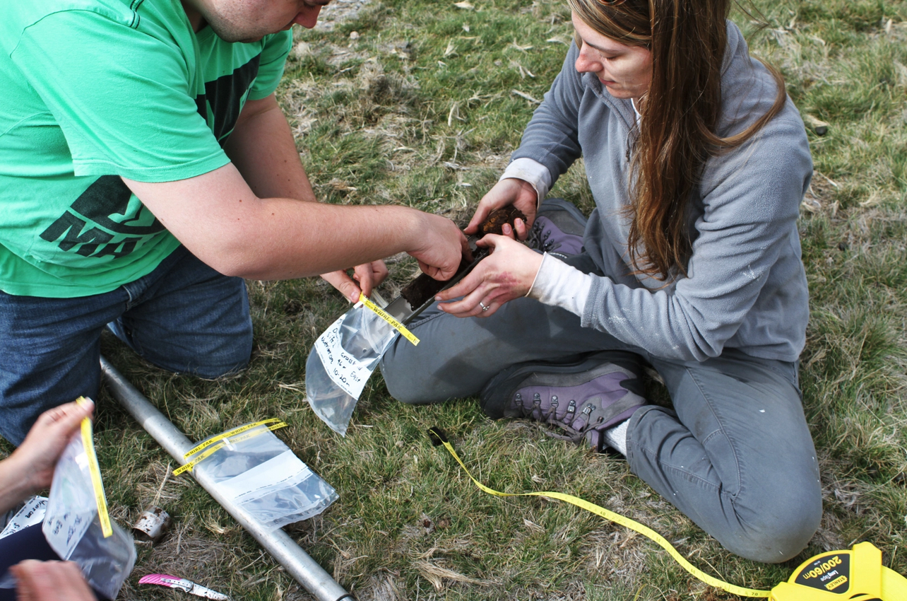
Our main research tools
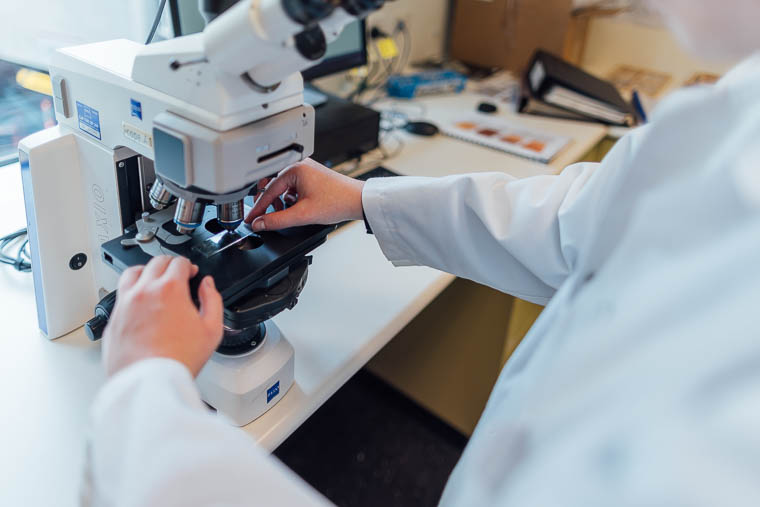
We primarily use pollen (for vegetation), charcoal (for fire) and tree-rings (for forest demography) to investigate human-environment relationships and changes in past environments and climate.
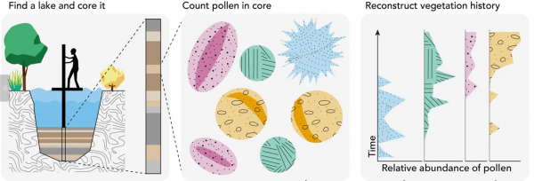
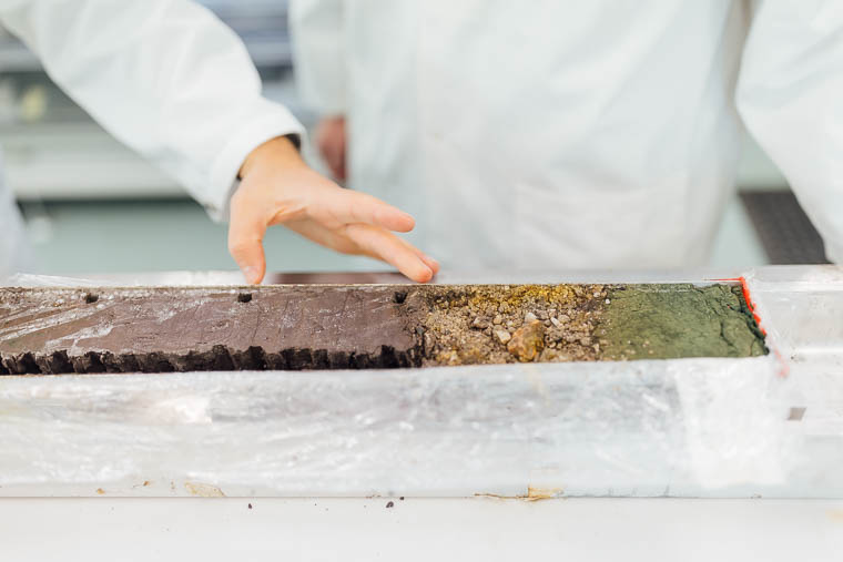
Vegetation (pollen)
Plants produce pollen that, thankfully for us, is unique in shape, texture and features. Pollen is transported primarily by wind (but also by insects, or other animals) that is then captured by wetlands and stored in their sediments. Counting the different types of pollen can tell us about vegetation changes over time.
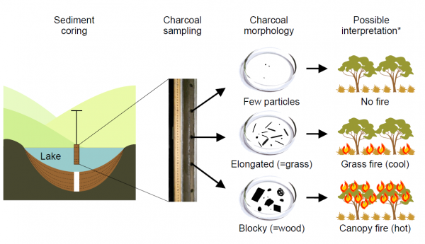
Fire (charcoal)
We use fossil charcoal stored in wetland sediments to look at past fire activity. No or few pieces of charcoal represent little to no fire whilst many pieces of charcoal represent lots of fire. The shape of charcoal can also tell us about the type of fire with long pieces representing cooler grass fires (e.g., cultural burning) whilst big, blocky pieces represent larger, hotter canopy fires (catastrophic fires).
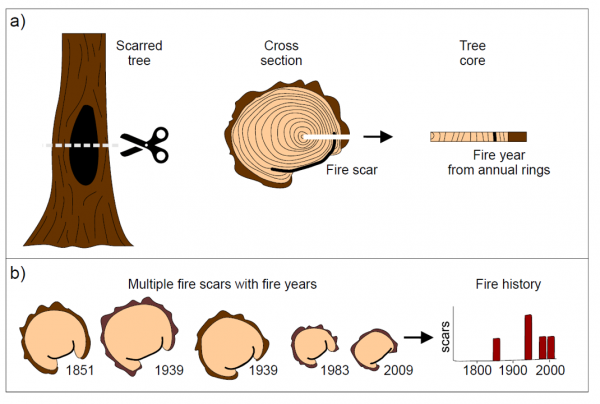
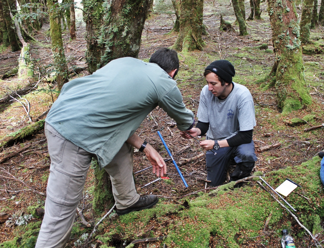
Tree-rings (dendrochronology)
We count tree rings to understand the age of forests, in particular rainforests in Tasmania. The more rings in a sample the older the tree is. Generally, we count backwards from the year the tree was cored to calculate its age.
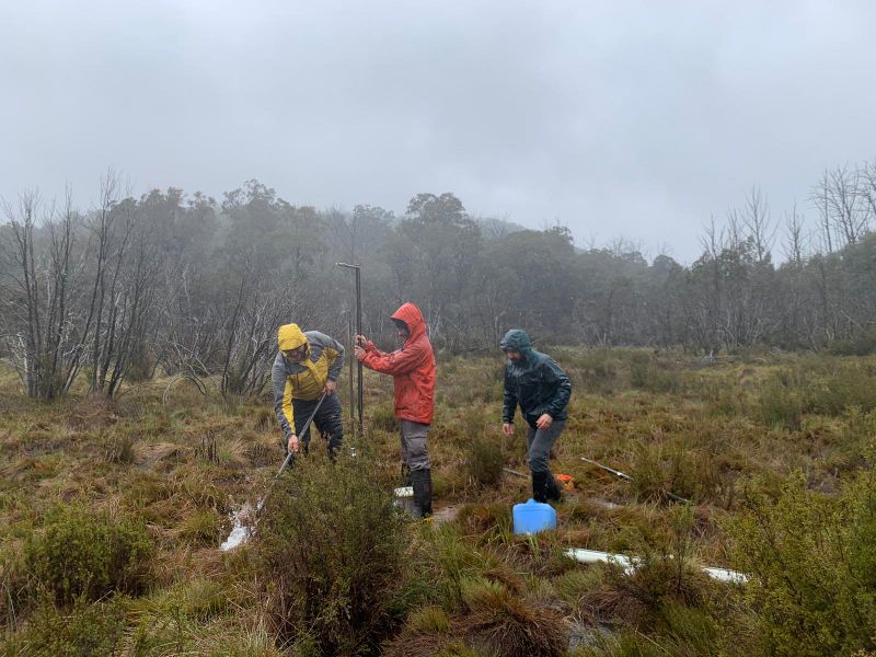
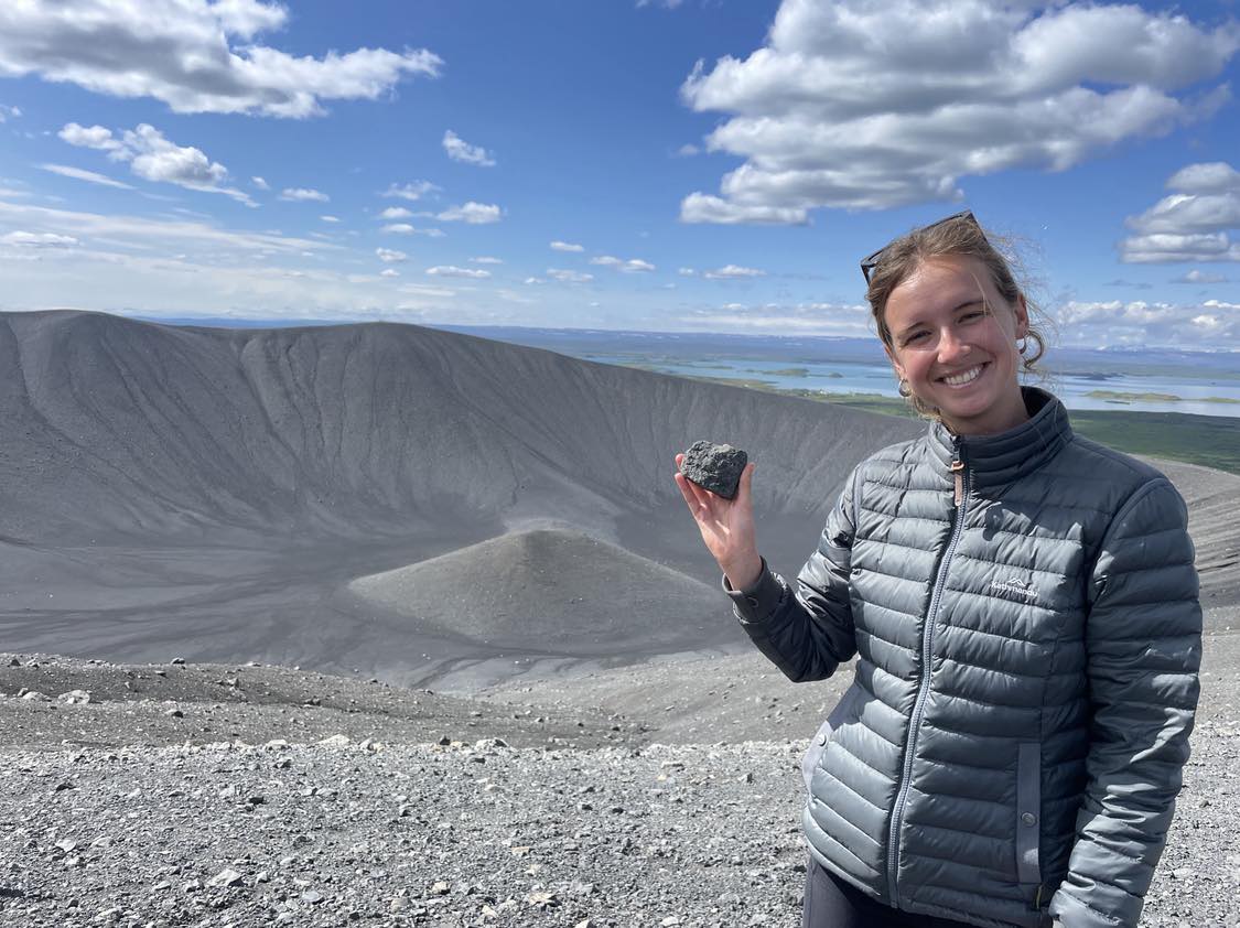
Sediment coring on Mount Buffalo (Victoria)
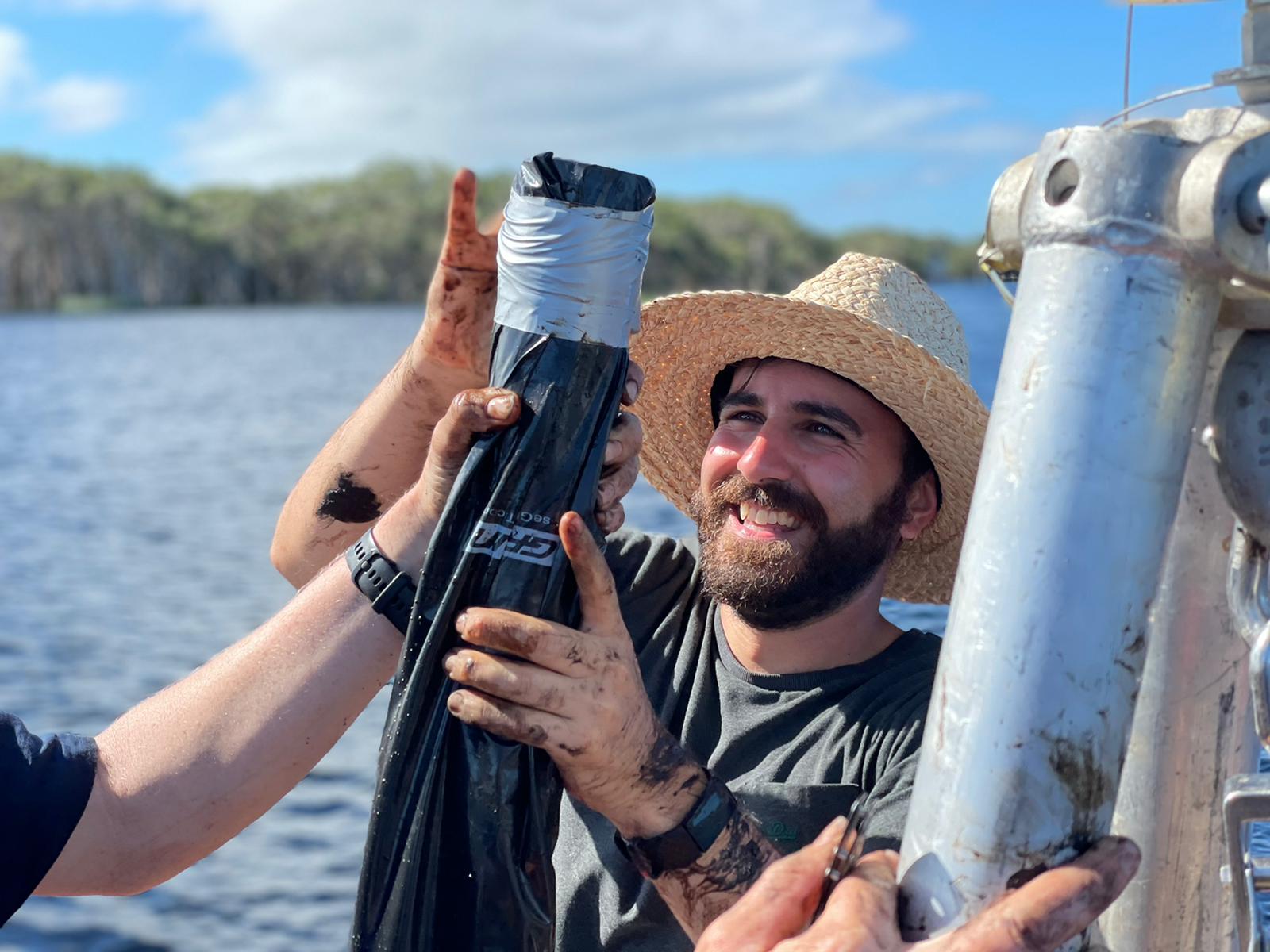
Sediment coring in Lutruwita (Tasmania)
Sediment Coring Bolin Bolin Billabong (Bulleen, Naarm/Melbourne).
Graduate research
Are you interested in graduate research with our research group? Take a look at our current research projects and enquire with us about what we have available.
Our research projects
Past Fire Frequency and Intensity REconstruction (PF-FIRE)
2021 - 2024
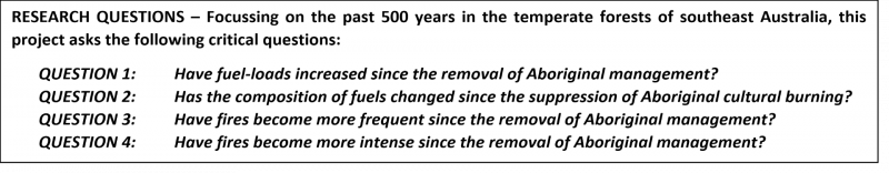
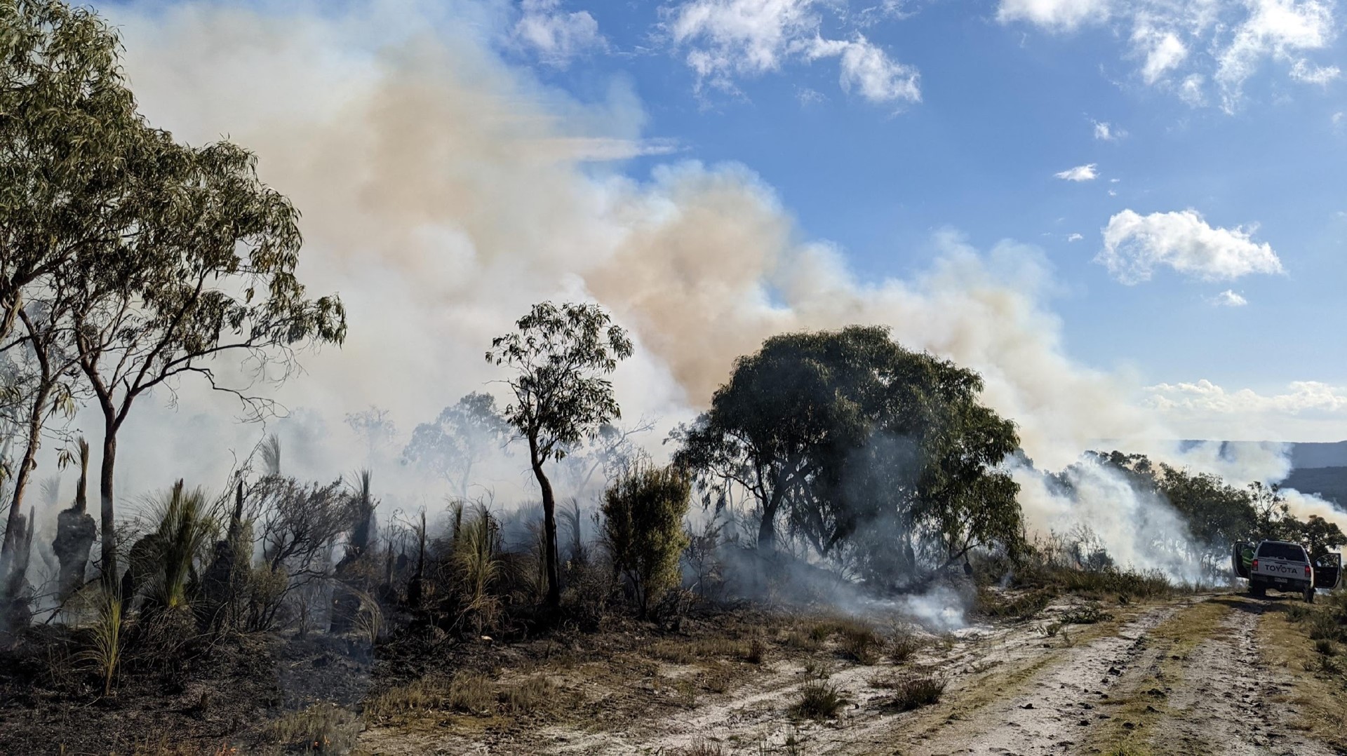
The austral summer of 2019/2020 saw the largest and most devastating bushfires in recorded history in Australia: the Black Summer Fires in southeast Australia. Australia is no stranger to fire, but have they always burned so hot? The biota of this vast, dry and nutrient depleted continent is finely attuned to fire. A relationship honed over millions of years of fire-biota feedbacks. In southeast Australia, forests are dominated by highly flammable Eucalyptus trees (sclerophyll forests).
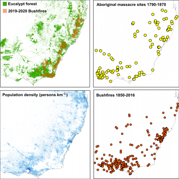
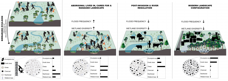
Aboriginal and Torres Strait Islanders – Australia’s First Peoples – recognised the key role that fire plays in Australian ecosystem dynamics and they have used fire to manage, manipulate and create Australian vegetation landscapes since arriving more than 68,000 years ago. Southeast Australia was owned and occupied by a diverse number of Traditional Owner groups who managed their Country with fire using small-scale, high frequency and low intensity burning – Cultural Burning. Cultural burning brings life to Country and keeps it open, clean and healthy.
Now, much of the southeast forest estate is managed with a fire-suppression mindset using hazard reduction burning around selected assets. Around 250 years ago, the British invaded the lands of Australia’s First Peoples. This marked the beginning of a continuing attempt to remove Aboriginal and Torres Strait Islanders from their Country and impose European-style land management regimes. This attempt has largely failed. The climate and geology is largely inhospitable to imported crops and livestock. The dependence on fertilisers and irrigation have exacted a significant toll on the Australian environment. The European attitude toward fire (characterised by fear) and “nature” have also had a major impact on the Australian environment. The attempt to remove Aboriginal and Torres Strait Islanders from Country and deny their skill and agency in shaping and managing Country with fire has caused widespread changes in vegetation across the continent.
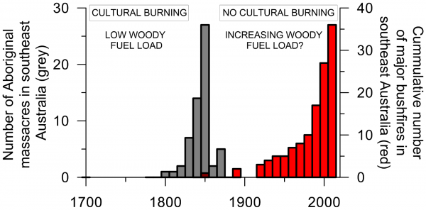
Further, the futile attempt to suppress and fight fires on this continent has deprived ecosystems of essential disturbance, increased fuel loads and produced sick Country. More recently, climate change has caused an increase in extreme weather events (heatwaves, droughts and floods), adding to the pressure Australian environment faces. These three key factors (removal of traditional management, importation of inappropriate methods and attitudes and climate change) have resulted in Australia experiencing the fastest rate of biodiversity loss on Earth. The Black Summer Fires were concentrated in southeast Australia. Southeast Australia experienced the first recorded catastrophic bushfire in 1850 (nearly a century after the British Invasion) and there has been a marked increase in the occurrence of large and devastating catastrophic bushfires toward the present day.
This project brings together a unique team of experts in Indigenous knowledge and practice, fire ecology, palaeoecology and ecological modelling to understand how fires and fuels have changed over the past 500 years in southeast Australia – a period that spans Aboriginal management through the British Invasion to the present climate change world.
Centre of Excellence for Indigenous and Environmental Histories and Futures
2024 - 2030
Australian lands and seas have been shaped by thousands of years of Indigenous engagement, innovation, and management. To plan for the future impacts of change in the Anthropocene we must understand both long- and short term interactions between people, climate, land, and sea
– a central vision of the United Nations 2030 Sustainable Development Goals. We will directly address the urgent need to develop sophisticated data and models of the dynamics of past changes, including catastrophic change, to make Australia’s social-ecological future more certain and secure.
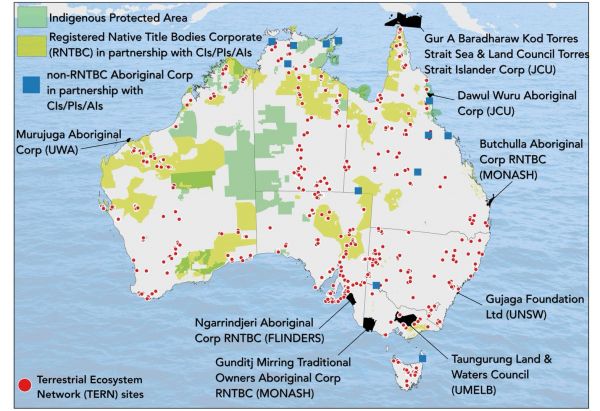 Location of Centre Indigenous Partner Organisations (in black). Green shading and blue squares show where Chief, Partner, or Associate Investigators have done partnership research on Country. Red dots: distribution of monitoring plots maintained by Partner Organisation Terrestrial Ecosystem Monitoring Network (TERN), a component of the National Collaborative Research Infrastructure Strategy.
We have devised an ambitious research, engagement, and training program centred on Indigenous partnerships and Caring for Country. By co-designing research with Indigenous partners, Indigenous knowledges will reframe Western science to understand environmental baselines as historically contingent and anthropogenic. By creating innovative Science, Technology, Engineering, and Maths (STEM) and Humanities, Arts, and Social Sciences (HASS) methods of high-resolution hindcasting and forecasting, we will create the first truly transdisciplinary and transcultural understanding of Australian landscapes and seascapes. This will be achieved by looking back 1000 years and forward 100 years. This will radically transform current short-term and a historical frameworks that underpin Western science based management and policy-making.
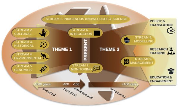 Research structure of the Centre of Excellence for Indigenous and Environmental Histories and Futures.
The Centre’s activities will have direct and enduring impact on the research, education, and public engagement sectors. The Centre will be a world-leading ‘point of reference’ for integrated
research at the interface between Indigenous and Western knowledges and sciences.
Our overarching intent is to catalyse a deeper recognition and broader uptake of Aboriginal- and Torres Strait Islander- led understandings of and approaches to managing land and sea Country. We will thereby positively influence public perceptions, and evidence-based policy-making on the central role that Indigenous knowledges and science must play in shaping sustainable futures for all Australians.
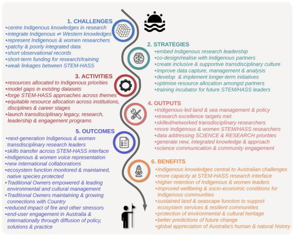 Strategy to translate Centre activities into outcomes and benefits.
Through a transdisciplinary research program, co-designed with Indigenous Partner Organisations, we will:
- Develop and communicate an integrated history of cultural and environmental change in Australia over the past 1000 years, informed by STEM and HASS research, reframed by Indigenous knowledges and Indigenous science, drawing from diverse cultural, environmental, and historical records.
- Build on regional land and sea Caring for Country activities, strategies, and policies through the integration of Indigenous knowledges with long-term, high-resolution hindcasting to situate current environmental baselines and issues in historical context.
- Forecast the trajectory of socio-ecological change under projected land-use, management, and climate change scenarios into the next hundred years.
In doing so, we will:
- Recruit, empower, and inspire the next generation of Indigenous researchers and create a pipeline of Indigenous undergraduate and postgraduate students at a critical juncture in closing the gap in higher education and research.
- Train the next generation of Indigenous and non-Indigenous research leaders in culturally appropriate, transdisciplinary methods and protocols, with particular focus on advancing Indigenous, women, and gender- diverse people across STEM and HASS.
The four central guiding questions are:
- How did Indigenous people engage with, and modify, lands, freshwater bodies, and seas across the last millennium in response to changing cultural, environmental, and climatic drivers, and what are the lessons for future management practices?
- How did Indigenous people adapt land and sea management strategies in response to increasing external contacts, beginning from at least the early 17th century with European and Macassan contacts, as well as earlier contacts from other maritime cultures?
- How did landscapes and seascapes respond to the cessation of active management by Indigenous communities in many parts of Australia (e.g. via fire) in response to permanent European occupation from the late 18th century? What were the implications for biodiversity, fire management, and sustainable fisheries (and other resources) practices?
- What are the implications of the answers to Questions 1–3 for constructing a new, extended environmental baseline to underpin future, effective, and sustainable land and sea management to obtain the best possible outcomes for Indigenous and wider community health and wellbeing in tandem with improved ecosystem health?
Traditional Owner-led restoration of urban billabongs.
2024 - 2027
In collaboration with Wurundjeri Woi Wurrung Cultural Heritage Aboriginal Corporation, Melbourne Water and the Waterway Ecosystem Research Group at the University of Melbourne this project aims to demonstrate the importance and efficacy of TO-led wetland management and
restoration using Melbourne’s degraded remnant riverine wetlands (billabongs) along the urbanised lower Yarra River (Birrarung). Rivers and wetlands have long been critical to human societies and hold significant cultural and ecological value. Despite their critical role in sustaining healthy societies and ecosystems, rivers and wetlands are some of the most degraded ecosystems globally. Wetlands that remain today are often under threat from human impacts such as changes to fire and flooding
regimes, urbanisation, and the spread of invasive plants and animals. Restoration of wetland health requires both knowledge of past ecosystem condition and local knowledge of management and care (i.e., knowledge held by Indigenous and local peoples). Indigenous peoples’ knowledge of wetland ecosystems stem from managing and identifying with their land and waterscapes for millennia.
For this project we will:
(1) Determine the historical ecological baselines and changes in fires, floods and vegetation of billabongs of the lower Birrarung (Yarra River) through Traditional Owner-led empirical investigations using sediment core analyses of charcoal, sediments, and pollen.
(2) Determine billabong vegetation, faunal and water quality responses to cultural burns and
wetting and drying through TO-led monitoring and assessment programs (including field-based surveys, environmental DNA analyses and water quality monitoring).
(3) Provide an exemplar of Traditional Owner-led investigations that inform the development
of restoration and sustainable management plans for culturally and ecologically significant urban wetlands.
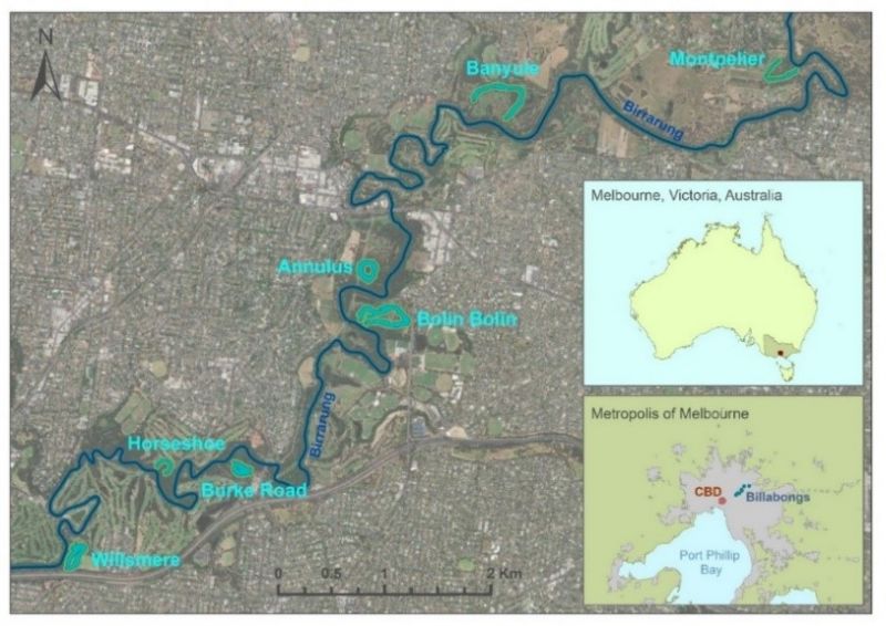
Seven remnant billabongs along the lower Birrarung will form the basis of this study: Annulus, Banyule, Bolin Bolin, Burke Rd, Horseshoe, Montpelier and Willsmere. These billabongs have previously been identified as sites of ecological and cultural significance under Melbourne Water’s Healthy Waterways Strategy.
Murnongs on Maar Country.
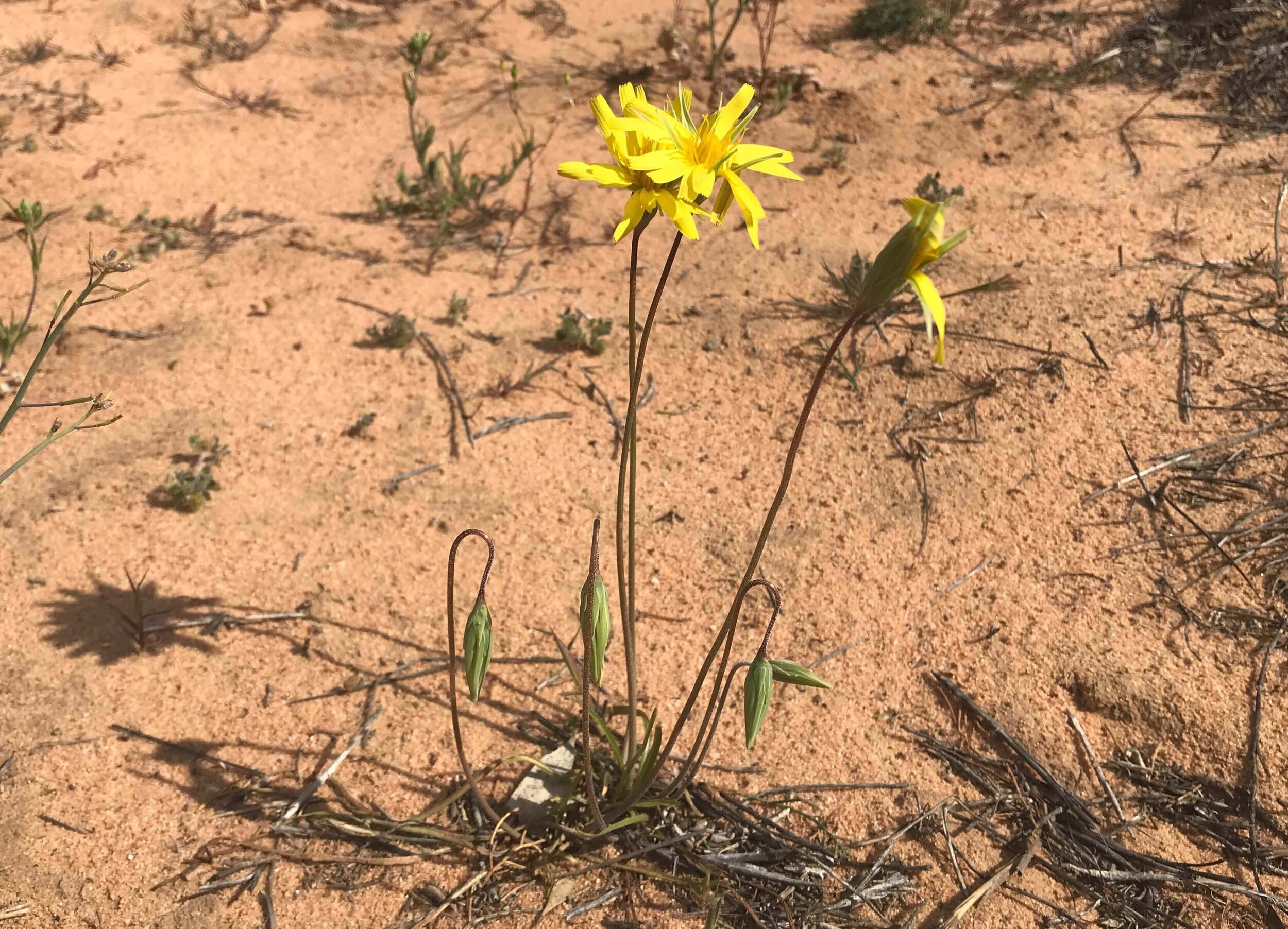
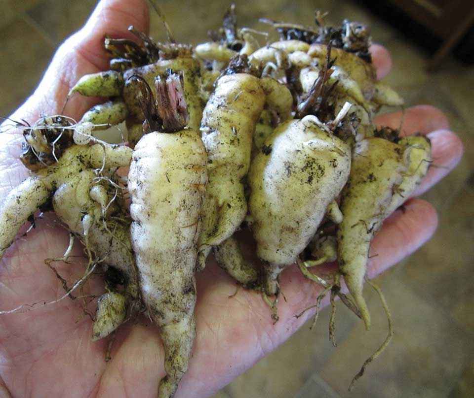
In collaboration with Eastern Maar Aboriginal Corporation, Conservation Ecology Centre, Zoos Victoria, Australian Institute of Aboriginal and Torres Strait Islander Studies and Glenelg-Hopkins Catchment Management Authority this project aims to provide the foundation for a revitalisation of Murnong (Microseris spp./Yam Daisy) cultivation using a novel combination of history, historical and contemporary ecology, palaeoecology and Aboriginal cultural knowledge. This project will take place across the lands of the Eastern Maar. Here, we will use an investigation of Murnong to illustrate how extensive and productive these food production systems were, what the biophysical environment of yam systems was like and how important they were both culturally and spiritually to the Eastern Maar people. This baseline data will provide information critical for understanding the community ecology and soil environment of Microseris spp. ecosystems, via the analysis of pollen. Further, charcoal stored in these sediments will shed light in the long-term role of fire in Microseris spp. agriculture. Core sampling will focus on lakes and wetland sediments adjacent to contemporary and historical areas of Murnong, to avoid disturbance from cultivation (digging) within Murnong fields.
In addition, we are also investigating the landscape across Carlisle Heath in the Otway region of southwest Victoria. This part of the project is looking into the role of fire and how appropriate and skilful application of fire can be used to manage fuel and biodiversity in the Carlisle Heath. Additionally, we are looking at how the vegetation has changed across the Carlisle Heath to understand what changes have occurred since Invasion and colonisation.
Recent publications
- Pascoe, J., Shanks, M., Pascoe, B., Clarke, J., Goolmeer, T., Moggridge, B., Williamson, B., Miller, M., Costello, O. and Fletcher, M.S., 2023. Lighting a pathway: Our obligation to culture and Country. Ecological Management & Restoration, 24(2-3), pp.153-155.
- Kelly, L.T., Fletcher, M.S., Menor, I.O., Pellegrini, A.F., Plumanns-Pouton, E.S., Pons, P., Williamson, G.J. and Bowman, D.M., 2023. Understanding Fire Regimes for a Better Anthropocene. Annual Review of Environment and Resources, 48(1).
- Henríquez, W.I., Fletcher, M.S. and Romano, A., 2023. Vegetation, fire and climate history in central-western Tasmania (41° S), Australia, over the last∼ 21,000 years. Quaternary Science Reviews, 318, p.108315.
- Beck, K.K., Fletcher, M.S., Wolfe, B.B. and Saunders, K.M., 2023. Aquatic ecosystem response to climate, fire, and the demise of montane rainforest, Tasmania, Australia. Global and Planetary Change, 223, p.104077.
- Laming, A., Fletcher, M.S., Romano, A., Mullett, R., Connor, S., Mariani, M., Maezumi, S.Y. and Gadd, P.S., 2022. The curse of conservation: empirical evidence demonstrating that changes in land-use legislation drove catastrophic bushfires in southeast Australia. Fire, 5(6), p.175.
- Fletcher, M.S., Pedro, J., Hall, T., Mariani, M., Alexander, J.A., Beck, K., Blaauw, M., Hodgson, D.A., Heijnis, H., Gadd, P.S. and Lise-Pronovost, A., 2021. Northward shift of the southern westerlies during the Antarctic Cold Reversal. Quaternary Science Reviews, 271, p.107189.
- Fletcher, M.S., Hamilton, R., Dressler, W. and Palmer, L., 2021. Indigenous knowledge and the shackles of wilderness. Proceedings of the National Academy of Sciences, 118(40), p.e2022218118.
- Fletcher, M.S., Romano, A., Connor, S., Mariani, M. and Maezumi, S.Y., 2021. Catastrophic bushfires, indigenous fire knowledge and reframing science in Southeast Australia. Fire, 4(3), p.61.
Biogeography of Fire (GEOG30025/90027)
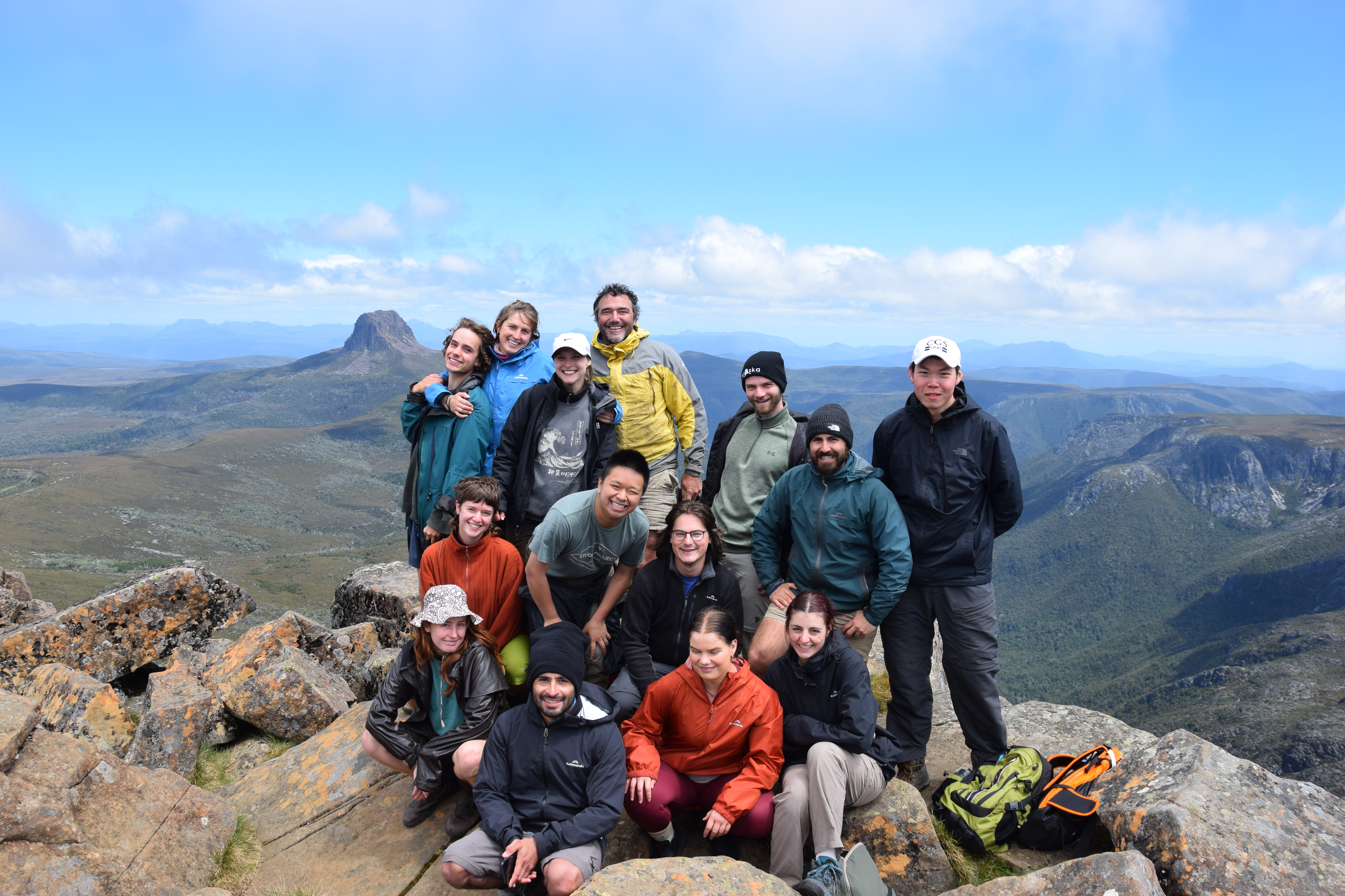
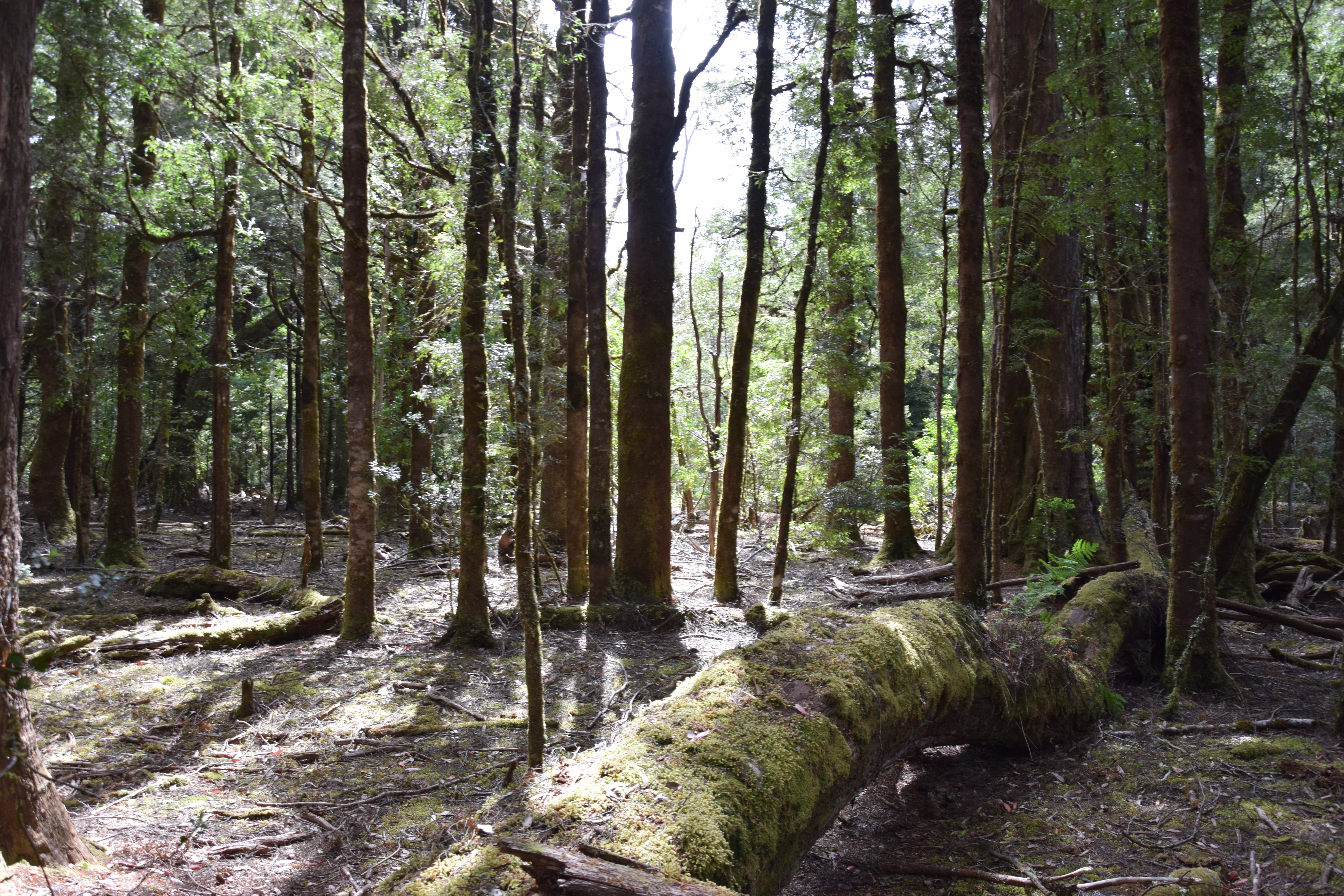
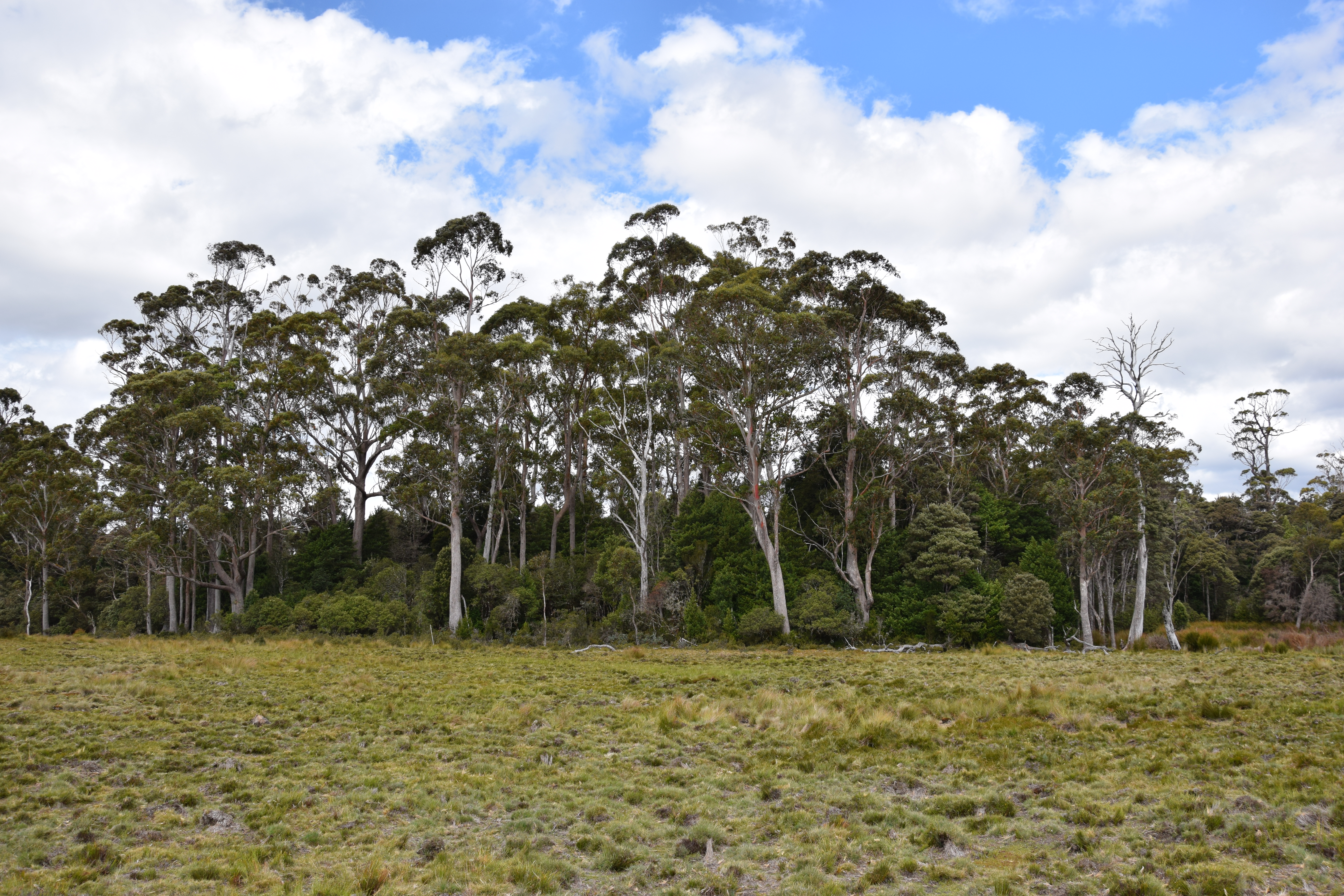
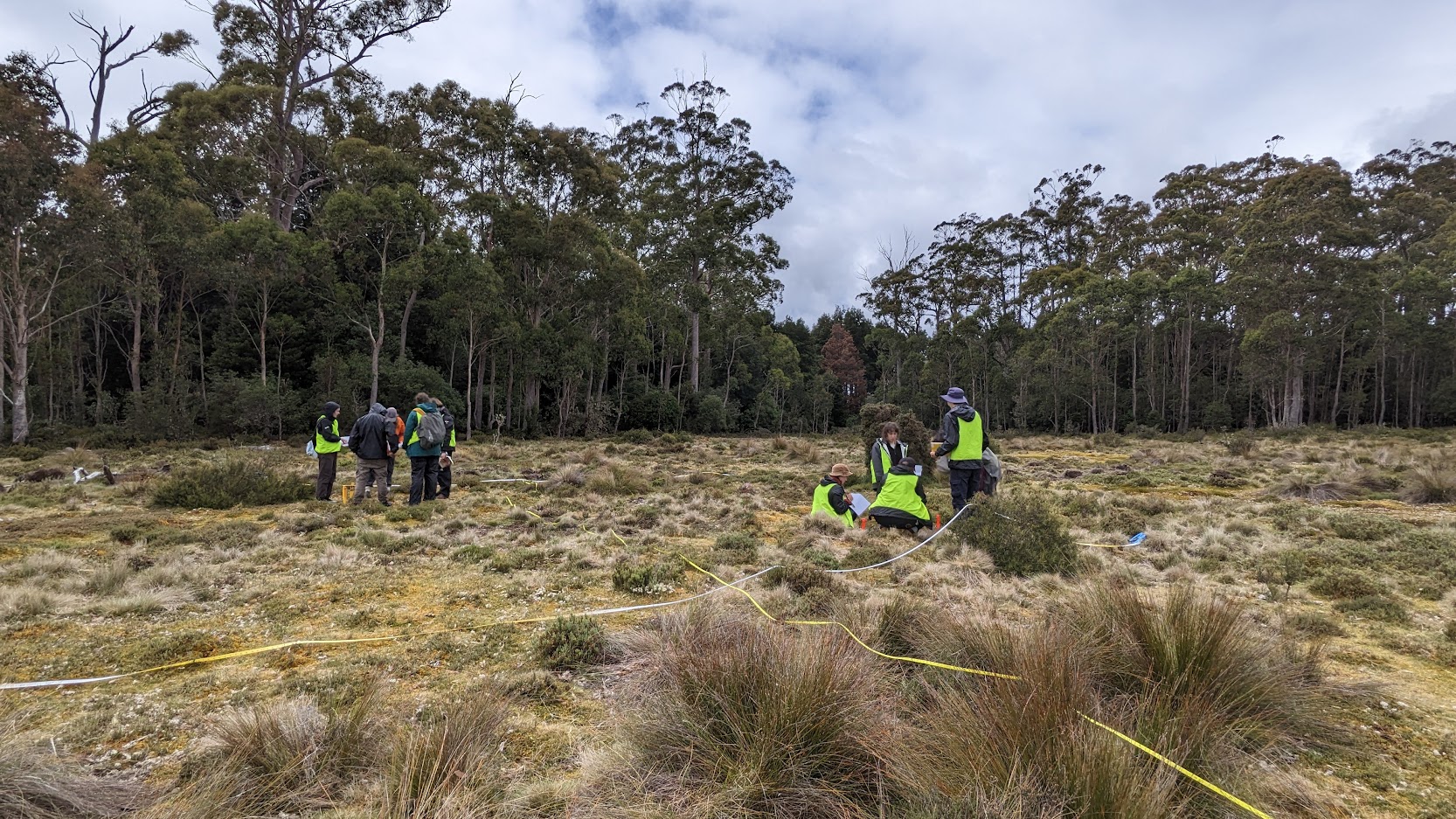
Fire is one of the most important controls over the distribution of vegetation on Earth. This subject examines the role of fire in natural systems, with a particular emphasis on the importance of fire in determining global vegetation patterns and dynamics over long periods of time. The aim is to understand how terrestrial systems have evolved to cope with and exploit fire, and to place the extreme flammability Australia's vegetation within a global context. The subject will examine concepts such as resilience, positive feedback loops, hysteresis and alternative stable states. The use of fire by humans to manipulate environments will be examined, with a particular emphasis on the variety of approaches employed by people across a diversity of environments over long periods of time, allowing an exploration of the social and cultural dynamics of fire and environmental management. A field excursion in Tasmania will visit a number of sites which will exemplify the subject themes. The practical exercises leading up to the field trip will focus on how to gather fire-related ecological data. The practical exercises following the field trip will be devoted to processing, analysing, interpreting and reporting on the field data. At the end of the subject, students will have gained an understanding of the way in which fire has shaped natural systems, as well as acquiring the skills necessary to formulate and test hypotheses.
Subject & field trip information
-
About the subject & field trip
This is a quota subject, with a maximum of 30 students. Selection is based on WAM, with preference given to University of Melbourne Geography majors. Successful enrolments will be notified in December and a deposit will be required to secure the place in the class.
The estimated additional cost of the 7-day field trip to Tasmania, is in the vicinity of $900-$1000. Students will be notified of the final cost. This cost covers all travel, accommodation and meals. This is not covered by HECS or University fees.
**Note: this subject may be taken as the Capstone subject in the Geography major of the BA and BSc. All students, whether they are capstone students or not, will be required to complete online introductory materials that are common across all field classes.
-
Important dates
Subject dates: Jan 19-Feb 13.
* Pre-field lectures: Jan 19 (these will not be recorded).
* 8-day field trip: Jan 22-29.
* Lectures will run between 11:30-12:30 each day between Jan 31-Feb 13.
* Laboratory sessions: Jan 31-Feb 13 (Each student must complete 14 hours laboratory hours as a minimum. These are in 2-hour slots (i.e., each person needs to do 7x2 hour sessions). There is a maximum of 8 people in each 2-hour slot. A booking sheet is released on Jan 30 and is on a first served, best dressed basis).
-
What you'll do
We are conducting a Natural Experiment – i.e., we are actually going to do science on an unsolved problem. We are interested in what determines the distribution of ecosystems. Our study area – Surrey Hills – is a great place to study this question, as there are remarkably sharp transitions between rainforest and grasslands. You will discover in the lectures that this kind of relationship is ‘unusual’ in nature and is always related to some factor holding the rainforest out. Our hypothesis, which is no surprise, is fire!
To test this, you will be using the full toolset available to a biogeographer (a person who studies the distribution of ecosystems): dendroecology (tree rings), palaeoecology (fossil analysis), palaeofire analysis (fire changes through time), soil nutrient analysis and botany (vegetation surveys).
You will work in ‘analysis groups’ in the field and in the lab to complete your groups’ sample collection and analysis. In the laboratory, this entails ~14 hours each of analysis in the Palaeoecology Laboratory at the University of Melbourne.
-
What to expect
Tasmania has complex weather. It can snow, rain, hail and shine at any time of the year and on any given day. You need to be prepared for this. Field work days are each 2×3 hour sessions in the field, plus 1 hour lunch. You will be some distance from vehicles, etc, throughout this time, so you need to prepare for this.
HATS and SUNSCREEN are a must at all times.
Tasmania has leeches. They are small, non-poisonous and don’t hurt when they bite, but you need to be mentally prepared for them.
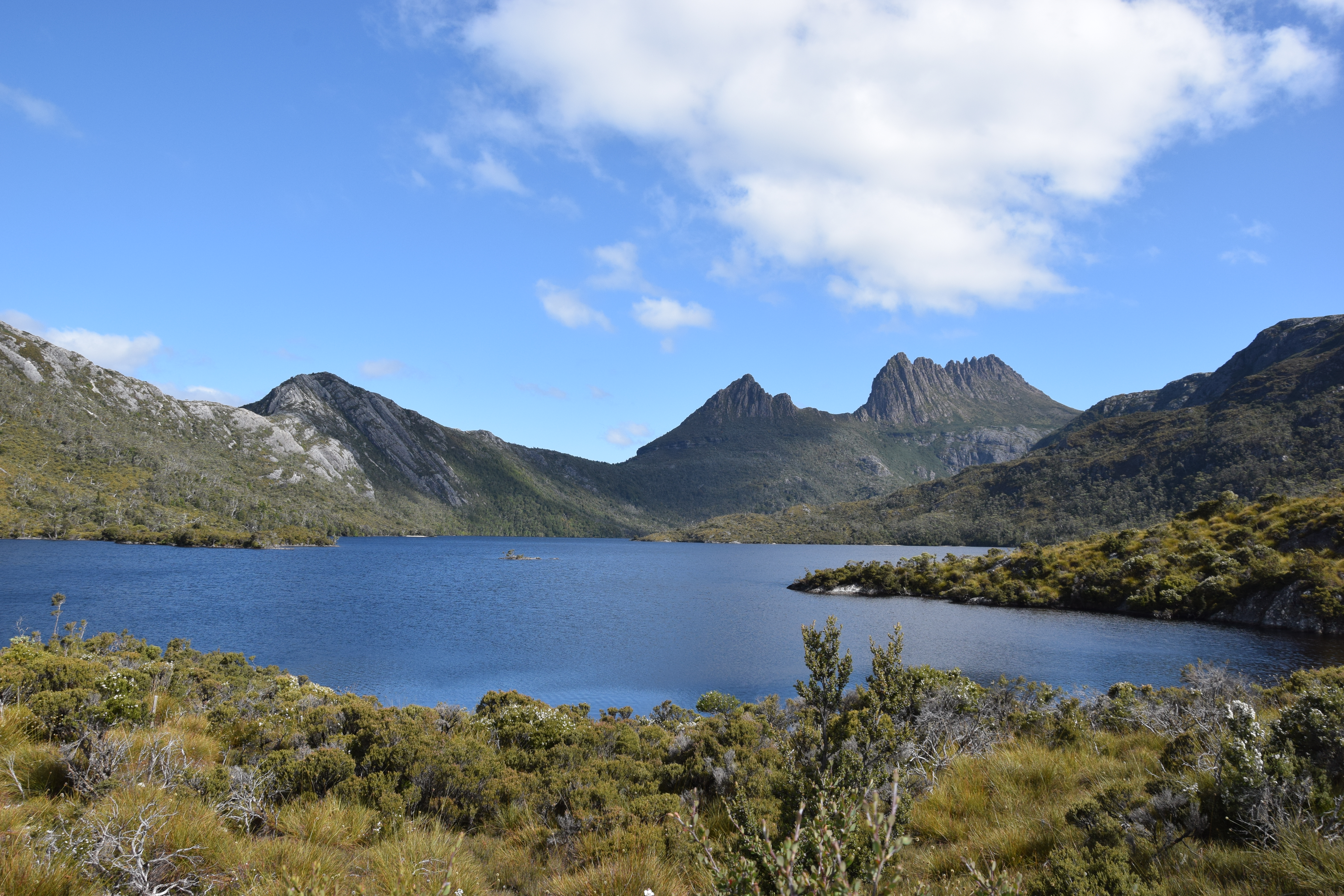
We will be working in relatively flat terrain, but where there are no walking tracks. You will need sturdy walking shoes that are either waterproof or that you don’t mind getting wet. The walks at Cradle Mountain vary in difficulty.
Download packing list -
Meals
Groups will be formed and a rotation system created so that food preparation and cleaning will be performed by everyone. You will make your own lunches each day at breakfast and we will eat between 6-7pm each evening. We will be conducting sampling prior to dinner if your group is not on meal preparation that evening.
We accommodate dietary preferences, but you may need to contribute to your own food preparation if it is highly specialised/restrictive.
-
Assessment
Field Journal due at end of field trip.
Four online reading assignments i.e., quizzes.
Group Presentation - 20 minutes duration, due after labs.
Individual report based on the analysis of field data, 2000 words (Nature-style paper) due a couple of weeks after labs.